
Lunada Bay Nursery
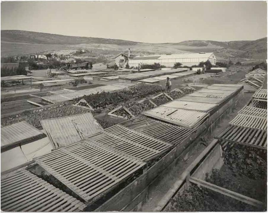
In late 1920, at a time when Malaga Cove was but a fledgling community, the surrounding Palos Verdes Peninsula was a coastal wilderness and this was the face of Lunada Bay. This nursery was an integral part of the Palos Verdes Project put forth by Olmsted Brothers Landscape Architects and Farnham B. Martin, Superintendent of Parks for the Palos Verdes Homeowners Association.
Together with a crew of Mexican workers hired alongside the Mexican teams grading the network of roads crisscrossing the peninsula with steam shovel and scrapers, Farnham Martin augmented the nursery’s supplies of plants, shrubs and saplings by trekking to Santa Barbara’s Montecito Estates. There he would offer to prune trees and clear overgrown shrubbery from that community which had also been landscaped by the Olmsted Brothers.
Returning to Lunada Bay with truckloads of twigs, he established a nursery of sometimes rare and always plentiful acquisitions available at cost to new property owners. Walking vacant lots sometimes at six o’clock in the morning, Martin offered advise on the best sun exposure and wind direction, planting trees even before ground was broken. “Let’s see what we can do for your garden!” was a typical offer from Martin who believed that “Plants are like children: they respond to the least bit of human kindness and care. The results you get with them are unquestionably in proportion to the attention you give to them.”
In the four years that Farnham Martin was involved with the Nursery at Lunada Bay, he planted over 600,000 trees. Farnham B. Martin Park is located next to the Malaga Cove Library in honor of his dedication and service – a reflection of his ideals and vision.
Dominator Shipwreck
![Photo By Robert J. Boser EditorASC (Own work) [CC-BY-SA-3.0 (http://creativecommons.org/licenses/by-sa/3.0)], via Wikimedia Commons](http://www.lbhoa.org/wp-content/uploads/Dominator_Shipwreck_1965.jpg)
The Greek freighter S.S. Dominator ran aground near Lunada Bay (just below Rocky Point) in 1961. It was carrying over 10,000 tons of wheat and beef from the Pacific Northwest. The ship was traveling close to the coast in dense fog, as the crew was preparing for a fuel stop in Los Angeles Harbor the ship was caught in the rocky reefs along the Palos Verdes coastline. After several attempts to return the ship to sea, it was abandoned and heavy surf drove the ship further into the rocks.
In the years following the wreck, the local lobster population fed on the leftover grain. A 1962 LA Times article “Shipwreck Is Headache to Palos Verdes People”, documents how the rotting meat was eventually set on fire to eliminate the spoiled meat odor that permeated the entire peninsula.
The ship has slowly been breaking up and melting away as the wreckage shifts between the rocks along the coast for the past 50+ years, very little remains visible above the water. Today it is a popular shoreline hike (as long as you are able to navigate the steep cliffs) during low tide. The wreckage underwater is also popular with area divers.
Douglas Cut/PV Drive West
The main thoroughfare through Lunada Bay is Palos Verdes Dr. West, originally named Granvia La Costa and called the Coast Drive during the early planning stages. It was made possible by cutting away a portion of Bluff Cove named “Douglas Cut”. Thousands of people came in 1923 to see the blasting powder discharge, creation of this scenic shoreline road enabled coastal access around the peninsula (from San Pedro to Redondo Beach).
Ever wonder why PV Drive West is so wide? Well the original plans included the usage of an electric railway down the center along with a landscaped median. The name ‘Douglas Cut’ is from the label on the surveyor’s cement monument that was placed on the highest elevation point during road construction preparations.